
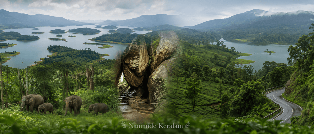
| Core Fact | Wayanad District Details |
|---|---|
| Geographical Location / Status | Hill district in north-east Keralam, located in the Western Ghats and bordering Karnataka and Tamil Nadu. |
| District Headquarters | Kalpetta |
| Total Land Area in sq km | 2,132 sq km |
| Population as per latest available Census data | 817,420 as per Census 2011 |
| Literacy Rate | 89.03% |
| Number of Rivers / Major Rivers | Exact official number not clearly available from official public sources. Major rivers include Kabani/Kabini, Panamaram, Mananthavady, and Thirunelli. |
| Revenue Divisions | 1 Revenue Division: Mananthavady |
| Taluks | Mananthavady, Sulthan Bathery, Vythiri |
| Municipalities | Kalpetta, Mananthavady, Sulthan Bathery |
| Number of Grama Panchayats | 23 Grama Panchayats |
| Assembly Constituencies | Mananthavady, Sulthan Bathery, Kalpetta |
| Lok Sabha Constituency / Constituencies | Wayanad Lok Sabha Constituency |
| Official District Website | Official District Administration Website: Wayanad District Portal |
What Makes Wayanad Unique?
Wayanad district is Keralam’s major highland district in the north-east.
It is known for hills, forests, plantations, wildlife, and tribal heritage.
Wayanad Keralam has a distinct identity among Keralam districts. It is not a coastal district. It is a plateau region connected to the Western Ghats and the Mysore Plateau.
The district came into existence on 1 November 1980. It was formed as the 12th district of Keralam. The official district source records that Wayanad was formed with Mananthavady, Sulthan Bathery, and Vythiri taluks.
The name Wayanad is commonly linked with “Vayal Nadu,” meaning the land of paddy fields. This reflects its older agrarian identity.
Wayanad has one of Keralam’s strongest tribal and forest-linked cultural profiles. Major tribal communities in and around Wayanad include Paniya, Kurichiya, Kuruma, Adiya, and Kattunayakan communities.
Malayalam is the main public language. Tribal languages and dialects are also part of the district’s cultural life. Kannada and Tamil are also heard due to border links.
Wayanad is important for Keralam tourism, agriculture, wildlife conservation, and inter-state road connectivity. It links Keralam with Karnataka and Tamil Nadu through hill roads and forest corridors.
The district is also known for coffee, pepper, tea, cardamom, arecanut, paddy, rubber, and other plantation crops. Agriculture and tourism strongly shape local livelihoods.
Geography and Administrative Profile
Wayanad district is located in north-east Keralam.
It lies in the Western Ghats. It has hills, valleys, forests, plantations, streams, and river systems.
Wayanad shares boundaries with Kannur and Kozhikode districts in Keralam. It also borders Karnataka and Tamil Nadu.
The district is part of a sensitive hill ecosystem. Forests and wildlife areas play an important role in land use, tourism, and public planning.
Kabani/Kabini is one of the major river systems connected with Wayanad. Keralam Tourism records Kabani as a major river of the district and a tributary of the Cauvery. Its tributaries include Thirunelli River, Panamaram River, and Mananthavady River.
Revenue Divisions
Wayanad has one revenue division:
| Revenue Division | Notes |
|---|---|
| Mananthavady | Revenue Divisional Office for the district |
Wayanad Taluks
Wayanad taluks are:
| Taluk | Local Importance |
|---|---|
| Mananthavady | Northern and forest-linked part of the district |
| Sulthan Bathery | Eastern town and major road-linked area |
| Vythiri | Western highland side, including Kalpetta region |
Wayanad Municipalities
Wayanad municipalities are:
| Municipality | Importance |
|---|---|
| Kalpetta | District headquarters and administrative centre |
| Mananthavady | Major town in northern Wayanad |
| Sulthan Bathery | Major town near the Karnataka and Tamil Nadu side |
Panchayat Structure
Wayanad district has 23 grama panchayats.
The district also has 4 development blocks: Mananthavady, Kalpetta, Sulthan Bathery, and Panamaram.
Major Towns and Urban Centres
Important towns and local centres include:
| Town / Centre | Importance |
|---|---|
| Kalpetta | District headquarters, collectorate, courts, offices, commerce |
| Mananthavady | Revenue division, health, education, forest-side access |
| Sulthan Bathery | Tourism, trade, inter-state road connectivity |
| Vythiri | Tourism and hill-road access |
| Meppadi | Plantation and tourism-linked local centre |
| Panamaram | Panchayat and agricultural area |
| Pulpally | Agricultural and border-side settlement area |
Major Places to Know in Wayanad
Edakkal Caves
Nearest location: Ambukuthi Hills, near Ambalavayal and Sulthan Bathery.
Why it is important: Edakkal Caves are among Wayanad’s most important archaeological sites.
Claim to fame: Keralam Tourism identifies Edakkal Caves as a prehistoric rock shelter known for ancient engravings.
Edakkal Caves contain pictorial drawings and engravings linked to ancient human settlement. The site is not a conventional cave, but a natural rock shelter formed by a large boulder between rocks.
Banasura Sagar Dam
Nearest location: Padinjarathara area, near Kalpetta.
Why it is important: It is a major hydel and tourism landmark in Wayanad district.
Claim to fame: Keralam Tourism identifies Banasura Sagar Dam as the largest earthen dam in India and the second largest in Asia.
The dam is surrounded by hills and reservoir landscapes. It is also linked with boating and hydel tourism activities.
Wayanad Wildlife Sanctuary
Nearest location: Muthanga and Tholpetty regions.
Why it is important: It is a major wildlife and forest conservation area.
Claim to fame: Keralam Tourism records that Wayanad Wildlife Sanctuary has two discontinuous pockets, Muthanga and Tholpetty, covering 344.44 sq km.
The sanctuary is part of Wayanad’s forest identity. It is known for elephants, forest habitats, and eco-tourism activities regulated by the Forest Department.
Thirunelli Temple
Nearest location: Thirunelli, near Mananthavady.
Why it is important: It is one of Wayanad’s major religious and heritage sites.
Claim to fame: Thirunelli is widely known for ancestral rites and the Papanashini stream tradition.
The temple is located near forested hill terrain. It is an important pilgrimage centre in northern Wayanad.
Kuruva Island
Nearest location: Kabani river region, near Mananthavady.
Why it is important: Kuruva Island is a riverine eco-tourism location.
Claim to fame: It is associated with the Kabani river system and Wayanad’s forest-water landscape.
The island area is known for bamboo, river channels, and controlled eco-tourism access. Visitor movement is subject to seasonal and forest department restrictions.
Citizen Services and Local Infrastructure in Wayanad
Administrative Centers
Wayanad district administration is centred at Kalpetta.
Important administrative offices include:
| Office / Centre | Location / Role |
|---|---|
| District Collectorate | Kalpetta Civil Station |
| Revenue Divisional Office | Mananthavady |
| Taluk Office | Mananthavady |
| Taluk Office | Sulthan Bathery |
| Taluk Office | Vythiri |
| Municipal Office | Kalpetta Municipality |
| Municipal Office | Mananthavady Municipality |
| Municipal Office | Sulthan Bathery Municipality |
| District Police Office | Kalpetta |
| District and Sessions Court | Kalpetta |
The Wayanad district administration covers revenue, elections, disaster management, public grievances, certificates, land records, and citizen services.
Health Infrastructure
Wayanad citizen services depend heavily on public hospitals and primary health institutions.
Important public health facilities include:
| Health Institution | Location / Role |
|---|---|
| Wayanad Government Medical College | Mananthavady |
| General Hospital | Kalpetta |
| Taluk Head Quarters Hospital | Vythiri |
| Community Health Centres | Meenangadi, Panamaram, and other local centres |
| Government Tribal Hospital | Nalloornad |
| District health administration | District Medical Office system |
Wayanad Government Medical College at Mananthavady is a major public health institution for the district.
Education Infrastructure
Wayanad has government, aided, professional, technical, and university-linked institutions.
Important education institutions include:
| Institution | Location / Role |
|---|---|
| Keralam Veterinary and Animal Sciences University | Pookode |
| College of Veterinary and Animal Sciences | Pookode |
| Government Engineering College Wayanad | Near Mananthavady |
| N.M.S.M. Government College | Kalpetta |
| Government College | Mananthavady |
| Government Polytechnic College | Meenangadi |
| Government Polytechnic College | Meppadi |
| Kannur University Mananthavady Campus | Mananthavady |
| K.M.M. Government ITI | Kalpetta |
Wayanad’s education profile includes arts and science colleges, technical colleges, veterinary education, engineering education, and skill training institutions.
Transport Infrastructure
Wayanad does not have a railway line inside the district.
Road transport is the main mode of access.
| Transport Facility | Local Relevance |
|---|---|
| Major bus stations | Kalpetta, Mananthavady, Sulthan Bathery |
| Nearest major railway stations | Kozhikode, Kannur, and Mysuru, depending on route |
| Nearest airports | Kannur International Airport and Calicut International Airport, depending on starting point |
| Major road corridor | Kozhikode–Kalpetta–Sulthan Bathery–Mysuru road corridor |
| Hill access route | Thamarassery Ghat Road from Kozhikode side |
Wayanad is important for inter-state road travel between Keralam, Karnataka, and Tamil Nadu.
There is no seaport or major water transport route inside Wayanad district.
Economy and Local Livelihoods
The economy of Wayanad district is shaped by agriculture, plantations, tourism, trade, and public services.
Agriculture is central to local livelihoods.
Major crops and sectors include:
| Sector | Local Importance |
|---|---|
| Coffee | One of Wayanad’s major plantation crops |
| Pepper | Important spice crop |
| Tea | Plantation crop in hill areas |
| Cardamom | Grown in suitable highland areas |
| Arecanut | Common in agricultural holdings |
| Paddy | Linked to the older “Vayal Nadu” identity |
| Rubber | Grown in parts of the district |
| Banana and vegetables | Important for local farming |
| Tourism | Supports homestays, resorts, guides, drivers, shops, and services |
| Animal husbandry | Linked with rural households and veterinary institutions |
| Small trade and services | Concentrated in Kalpetta, Mananthavady, and Sulthan Bathery |
Keralam Tourism notes that Wayanad’s high-altitude conditions support coffee, tea, pepper, cardamom, and rubber plantations.
Wayanad Robusta coffee has also become an important district identity in public branding and local enterprise discussions.
Tourism provides income through transport, accommodation, food businesses, guides, eco-tourism, and local products.
Culture, Language, and Society
Wayanad has a mixed cultural profile.
Malayalam is the main language used in administration, education, media, and public life.
Tribal languages and dialects form an important part of the district’s cultural identity. Kannada and Tamil are also present due to border connections.
Wayanad’s society includes tribal communities, farming communities, plantation workers, traders, service workers, and migrant-settled families.
Major religious and social traditions include temple festivals, church festivals, mosque-linked community events, tribal cultural practices, and local harvest-linked customs.
Important cultural and heritage features include:
| Cultural Feature | Local Importance |
|---|---|
| Tribal heritage | Strong presence in Wayanad’s society and identity |
| Folk traditions | Linked to tribal, agrarian, and forest-side communities |
| Religious festivals | Celebrated across temples, churches, and mosques |
| Agricultural lifestyle | Strongly visible in villages and plantation areas |
| Food identity | Rice, tapioca, local vegetables, spices, coffee, and Malabar-influenced food habits |
| Heritage sites | Edakkal Caves, Jain heritage traces, temples, churches, and old settlements |
Wayanad local information is closely connected with land, forests, agriculture, and inter-state movement.
Wayanad Local Information Summary
Wayanad at a glance can be understood through four core identities.
First, Wayanad is Keralam’s highland district.
Second, Wayanad district administration is centred at Kalpetta.
Third, Wayanad taluks are Mananthavady, Sulthan Bathery, and Vythiri.
Fourth, Wayanad tourist places are closely linked with forests, caves, dams, wildlife, plantations, and hill landscapes.
Wayanad citizen services are mainly accessed through the Collectorate, RDO office, taluk offices, municipalities, grama panchayats, hospitals, police offices, courts, and local self-government institutions.
Suggested Official Sources to Verify
Official District Administration Website
Keralam Government Portal
Keralam Tourism
Census of India
Local Self Government Department, Keralam
Keralam Legislative Assembly
Chief Electoral Officer, Keralam
Election Commission of India
Keralam Health Department
Keralam Forest Department
Directorate of Collegiate Education, Keralam
Keralam Veterinary and Animal Sciences University
Frequently Asked Questions About Wayanad
What are the taluks in Wayanad district?
The taluks in Wayanad district are Mananthavady, Sulthan Bathery, and Vythiri. These three taluks form the main revenue administration structure of Wayanad district.
What is Wayanad district famous for?
Wayanad district is famous for its Western Ghats hill landscape, forests, wildlife sanctuary, Edakkal Caves, Banasura Sagar Dam, coffee and spice plantations, tribal heritage, and inter-state border importance in north-east Keralam.
Which are the major tourist places in Wayanad?
Major tourist places in Wayanad include Edakkal Caves, Banasura Sagar Dam, Wayanad Wildlife Sanctuary at Muthanga and Tholpetty, Thirunelli Temple, Kuruva Island, Chembra Peak, Pookode Lake, and Soochipara Falls.